BUY NOW! – $14,500. 00
If you are interested in reserving this parcel, click “Reserve Now” button for any of the payment options. You will be redirected to our payment page to make the initial reservation payment.
This is a GREAT place to build your dream. It gives you a feeling of peace and quiet being away from the city yet you are just a few minutes away from it all.
Parcel Size
Nearest Cities
State
Parcel #
County
Legal Description
40.00
ACRES
Navajo
COUNTY
Unpave Road: Power Line Rd, Woodruff, Arizona
ROAD
Exist
POWER
Hauled
WATER
Can be Installed
SEPTIC
34°47’29.2″N 110°00’28.9″W
COORDINATES
A-General
ZONING
5237ft-5256ft
ELEVATION
40 Acre Property with Dirt Road Access, 22 minutes from downtown Woodruff City. There are electricity lines & poles in place beside the property.
An hour from the property you will find the Black Mesa Ranger District that contains the Cucharas River and Cucharas Canyon. Activities include:
-Target Shooting
-Bicycling.
-Camping & Cabins.
-Fishing.
-Hiking.
-Horse Riding & Camping.
-Nature Viewing.
-OHV Riding & Camping.
-Outdoor Learning.
The Property has Road- Power Line Road . The Road to the Property connects to County Road- Arizona State Route 77. This is a State Highway approximately 6.2 miles to the South. This road traverses much of the state’s length, stretching from its northern terminus at the boundary of the Navajo Nation north of Holbrook to its junction with I-10 in Tucson.
About 40 minutes from the property, where you will find groceries, fuel, supplies, restaurants, medical care, schools, and professional services.
You can own a mighty piece of land. So what are you waiting for? Call us NOW at 541-494-7741!
AMENITIES:
-Nearby land owners either install water wells or haul it themselves.
-Electricity cables are beside the property
-Waste-16.9 miles away from the property
Approximate Distance to Nearby Cities & Points of Interest:
-52 minutes to DoBell Ranch
-50 minutes to Rainbow Forest Museum
-48 minutes to Rainbow Forest
-50 minutes to Long Logs Trail
-48 minutes to Agate House Museum
-36 minutes to Wigwam Motel
-36 minutes to Globetrotter Lodge
-36 minutes to Romo’s Restaurant
-34 minutes to Joe & Aggie’s Cafe
-35 minutes to Holbrook, AZ
-44 minutes to Snowflake, AZ
-47 minutes to Joseph City, AZ
-50 minutes to Taylor, AZ
Clinic/ Hospital:
-38 minutes to North Country Community Health Center
-48 minutes to Summit Healthcare Snowflake Medical Center
School:
-33 minutes to Navajo County Schools Superintendent
-38 minutes to Park Elementary School
-38 minutes to Holbrook High School-Alternate
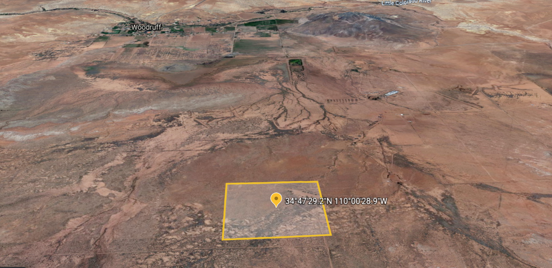
GPS Coordinates
-Northwest Corner:34°47’35.3″N 110°00’37.3″W
-Northeast Corner: 34°47’35.5″N 110°00’21.4″W
-Southeast Corner: 34°47’22.3″N 110°00’21.1″W
-Southwest Corner: 34°47’22.2″N 110°00’37.1″W
-Center Point: 34°47’29.2″N 110°00’28.9″W
Compare listings
ComparePlease enter your username or email address. You will receive a link to create a new password via email.